|
 |
History in
a Pecan Shell
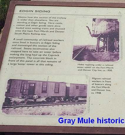
Gray Mule and Edgin
were suggested for inclusion by David Higgins of Lubbock,
Texas who also provided some recent photos and the information
below:
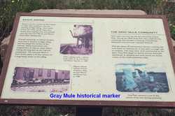
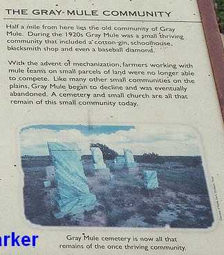
"Gray Mule was a thriving community in the 1920's that included a
cotton gin, schoolhouse, blacksmith shop and even a baseball diamond.
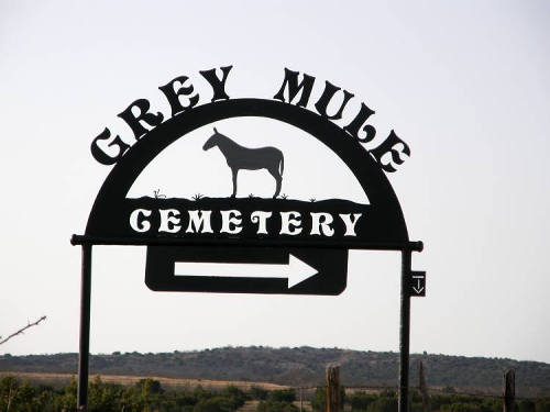
We were able to find the only remnants of this community at the Edgin
Cemetery, which is shown on the historical marker (it says "Gray Mule
Cemetery" but the actual name is Edgin Cemetery).
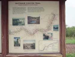
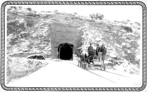
The Nature Trail
This nature trail is part of an old railroad that stretched from South
Plains, Texas to Estelline,
Texas and includes the "Clarity Tunnel" that was constructed /
carved out of a mountain in 1927. The tunnel is about 2.5 miles southwest
of the Gray Mule marker and measures about 1/8 mile in length. It
is now home to hundreds of Mexican free-tail bats (completely harmless).
We have visited the tunnel twice this year and were totally amazed
at how the railroad crews were able to build this huge tunnel......in
1927. It is still in very good condition.
The entrance to the nature trail is located 5 miles South of Quitaque
on FM 1065, then 2 miles west on FM 689."
- David Higgins of Lubbock,
Texas, September 13, 2005 |
|
|
Gray
Mule Historical Marker
Photo
courtesy David Higgins, 2005 |
Edgin
Siding - Gray-Mule Community Historical Marker
Photo
courtesy David Higgins, 2005 |
Gray-Mule
Community Historical Marker
Photo
courtesy David Higgins, 2005 |
Photographer's
Note:
Gray Mule was just up the road north of the cemetery.
Interesting how the spelling has changed. - Barclay
Gibson, September 15, 2010 |
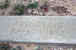
"Unknown
Cowboy
First Grave
Approx. 1890"
Photo courtesy David Higgins, 2005 |
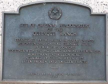
Quitaque Ranch
Headquarter Marker, 1936
Photo (taken at the same cemetery) shows this site was the original
headquarters of the Quitaque Ranch."
- David Higgins, 2005 photo |
| Remembering
Gray Mule
by Billie Mayhall
Freeman
Gray Mule was officially named Edgin as it was at first a
place where the trains stopped to put on more water for its engines
which I guess were steam. I am not sure of who started calling it
Gray Mule but it never showed up on maps, and probably neither did
Edgin. It was always called Gray Mule by locals and probably everyone
else except the train folks.
|
The School
When we lived in that area, Gray Mule had a school up to maybe the
sixth grade which was three rooms. One room was for the first through
the third and another room for the 4th and up. The other had been
planned for growth which never happened and was used for storage and
school parties and activites for the public. I remember a cousin winning
a jar of pickles for being the ugliest man there and I was so proud
to have a celebrity in the family. In later years he never remembered
that. I never forgot it. There were outdoor toilets with catalogs
when we were lucky. The school was a nice brick building across the
road north from the store.
There was also a teacher's residence on the grounds. Our two teachers
were a married couple named Roy L. Jamison and his wife, whose name
just slipped from my instant memory. It will come back for brief visits.
The "Graveyard" and the Land
We returned to that valley often over the years and saw it as these
structures slowly disintegrated and were plundered. The foundation
showed up for a very long time but we saw no sign of it for the last
20 years perhaps. That is a wild guess. The "graveyard" remains
down the road west of where the school stood and in a pasture to the
north and is now well marked, but for a long time was hard to find
for strangers. It is on private land. It remained well tended when
we were there last, about 3 years ago. There are quite a few of the
pioneer's descendants living in that area still, more in Quitaque
now. But some remain on farms out that way also. The land is marginal
for farming and still depends primarily on rain which varies widely
from year to year. It is beautiful scenery there just at the foot
of the red clay caprock drop off from the high plains of Texas.
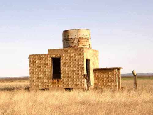
Identifying the Last Standing Structure
The tank in the photo is probably the one that fed the water for the
trains. I dont ever remember having seen that structure standing alone
there in later years, but the view north to the railroad tracks from
the road was obstructed by mesquite trees during the spring and falls
when we usually took our trips there. I heard the trains more than
I saw them and they were never very frequent except for the Doodle
Bug that later carried the mail up and back from the plains area.
The windmill and water storage tank and buildings below them near
the store (as shown partially
in my photo) are built in the same style and I remember it well as
it was cool in summer to play in the small building and the door setups
and tank appear much the same. |
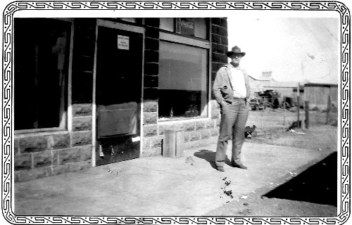 |
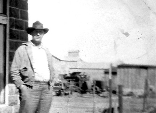
| "A photo
of my Dad standing in front of the store's plate glass window."
|
| "The Cotton
Gin (background) was owned or run by the Keisling family."
|
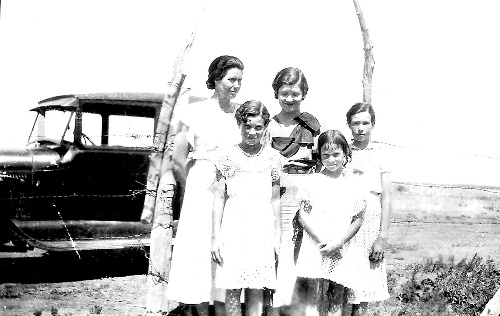
Life &
Times
I had a pet hen raised from a little chicken that shared that back
yard with me. It would get in the cars of folks who left their car
doors open which was common then. It would always be returned as our
friends knew it was my pet. But one day it got in the wrong car and
was not seen by me again. I still think of Sweet Pea from time to
time even though I have seen many pets come and go since then.
I have always had good memories of my childhood there, of the good
people we knew, the horses we rode to school at times and when we
walked across Quitaque creek, one of the tributaries leading
into the Pease River which joins the Red River which
we called uphill both ways. This was because of what seemed to be
at the time, a steep incline on either side of the creek through which
ran a little stream most of the time and could be fierce after a heavy
rain up on the caprock. At those times it came down with a roar and
those few families near enough would go down to "see the water come
down". Large boulders were not uncommon and getting cars and wagons
stuck was not uncommon.
Gray Mule is located between the Los Lingos and Quitaque
Creeks which had no bridges over any of those crossings when we
moved there in the early 1930's. It still rained at that time, but
before long that stopped but worse things were in store, such as almost
no rain at all for a very long time. We were on the inside edge of
the dust bowl during the same years as the Great Depression. That
was the reason we had to move to Quitaque.
Before the 1950s my family had all left that area for the high plains
and no more farming. I was the only member of my family that appeared
to remember it with such kind thoughts. But then I was the happiest
most cheerful of the four girls then later two much younger brothers.
Me and my brothers are the only surviving members of my family.
With many thanks and kind regards,
Billie Mayhall Freeman, September 16, 2010 |
 |
|
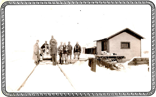
Railroad section
crew by their quarters.
|
| "I started
school at Gray Mule and my Dad ran the store there for a short time.
I have some photos of the
railroad tunnels...." - Billie Mayhall Freemana |
Railroad Tunnel
and Section Crew in snow
1930s
photos courtesy Billie Mayhall Freeman |
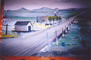
"A painting
of what Gray Mule looked like back in the 1930s by Dude Purcell."
- Courtesy
Renita Purcell Marshall |
"My grandparents
- Otis and Bessie Purcell - built the first grocery store in Gray
Mule in 1929. Their fourth child Otis Dean was born in 1930 in the
living quarters of the grocery store.
This is a painting of what Gray Mule looked like back in the 1930's.
Dude Purcell, my great uncle, painted the picture from memory for
my Dad Otis Dean Purcell. My family donated the painting in my dad's
memory to the Farimont Baptist Church in 2005 after my Dad died. Fairmont
Baptist Church is between Gray Mule and Quitaque,
Texas." - Renita Purcell Marshall, September 29, 2010 |
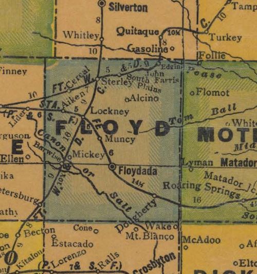
Floyd
County TX 1940s map showing Edgin,
the Fort Worth & Denver Railway, Quitaque
& Floydada
From Texas state map #4335
Courtesy Texas General Land Office |
| Texas
Escapes, in its purpose to preserve historic, endangered and vanishing
Texas, asks that anyone wishing to share their local history, stories,
landmarks and recent or vintage photos, please contact
us. |
|
|